
Waec 2025 Authentic Geography Practical Answers
Welcome to “EXAMRUNZ.COM” For Waec 2025 Expo
Questions & Answers

Thursday, 29th May_2025
Geography 3 (Practical and Physical Geography): 2:00pm –
3:50pm
GEOGRAPHY PRACTICAL ANSWERS
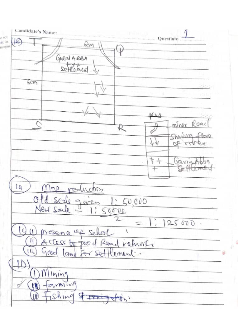
(1c)
(i)Transport Junction: KARLAHI is located at the intersection of major and minor roads, making it a central hub for transportation and communication within the mapped area.
(ii)Largest Settlement: It is visibly the largest settlement on the map, indicating a higher population density and more developed infrastructure compared to other settlements.
(iii)Presence of Institutions: KARLAHI hosts key facilities such as a school, a market, and possibly other services (as shown by symbols), which attract people from surrounding areas for education, trade, and services.
(1d)
(i)Farming and Agriculture: The map shows extensive farmland and scattered rural settlements, indicating that crop farming and possibly livestock rearing are primary occupations.
(ii)Trading/Commerce: The presence of markets (indicated by market symbols) shows that trading is a significant economic activity, with goods likely being exchanged within and outside the region.
(iii)Education: The presence of schools (school symbol) suggests that teaching and educational services contribute to the local economy, providing employment and attracting students from nearby villages.
NUMBER 3
(3a)
A lithosphere is the solid outer layer of the Earth, consisting of the crust and the uppermost part of the mantle. It is rigid and forms the Earth’s landforms, such as mountains, valleys, and ocean basins.
(3b)
(PICK ANY THREE)
(i) It is the outermost solid layer of the Earth.
(ii) It includes both the crust and the upper part of the mantle.
(iii) It is rigid and brittle in nature.
(iv) It is broken into tectonic plates that move over the asthenosphere.
(v) It contains both continental and oceanic crust.
(vi) It plays a role in the formation of landforms through geological processes like folding and faulting.
(3c)
(PICK ANY FIVE)
(i) Source of minerals: The lithosphere contains valuable minerals like gold, iron, and copper used in industries.
(ii) Supports agriculture: It provides soil which is essential for growing crops and feeding livestock.
(iii) Habitat for living things: Humans, animals, and plants live on the land provided by the lithosphere.
(iv) Foundation for infrastructure: Buildings, roads, bridges, and other structures are built on the lithosphere.
(v) Source of fossil fuels: Resources like coal, oil, and natural gas used for energy come from the lithosphere.
(vi) Controls geological activities: Processes like earthquakes and volcanic eruptions originate in the lithosphere.
(vii) Supplies raw materials: Materials like clay, sand, and limestone used for making cement and glass come from it.
(viii) Supports scientific study: Rocks and fossils found in the lithosphere help scientists understand Earth’s history.
NUMBER 4
(4a)
An artesian well is a type of well drilled into a confined aquifer where water is under natural pressure, causing it to rise to the surface without pumping.
(4b)
(PICK ANY FOUR)
(i) Presence of a confined aquifer: A water-bearing rock layer must be trapped between two impermeable layers.
(ii) Adequate water recharge: There must be a sufficient source of water (e.g., rainfall) at a higher elevation to recharge the aquifer.
(iii) Impermeable layers above and below: These prevent water from escaping, increasing pressure inside the aquifer.
(iv) Aquifer must be inclined or tilted: So that the recharge zone is higher than the discharge point.
(v) Sufficient water accumulation over time: This builds up the pressure needed for the water to rise naturally.
(vi) Proper geological structure: Folds or basins help trap water in the confined aquifer, aiding artesian flow.
(4c)
(PICK ANY TWO)
(i) Provides a constant water supply: Useful for domestic, agricultural, and industrial needs.
(ii) Does not require pumping: Saves energy and reduces operational costs.
(iii) Reliable during dry seasons: Offers water when surface sources may dry up.
(iv) Less risk of contamination: The water is drawn from deep, protected layers.
(v) Supports irrigation: Useful for watering crops in dry or semi-arid areas.
(vi) Can supply clean drinking water: If properly maintained, the water is often clean and safe.
NUMBER 6
(6a)
A flood plain is a flat, low-lying area of land found along the sides of a river, which is periodically flooded when the river overflows its banks. It is formed mainly by deposition of sediments during flooding.
(6b)
[DRAW THE DIAGRAM]
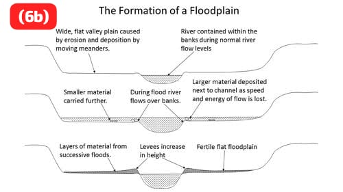
=CHARACTERISTICS OF A FLOOD PLAIN=
(i) Flood plains are usually broad, flat areas adjacent to a river channel.
(ii) The soil is often very fertile due to the regular deposition of nutrient-rich sediments during floods.
(iii) Flood plains experience periodic flooding when the river overflows its banks.
(iv) They often have meanders (curves or bends) in the river channel.
(v) The area supports lush vegetation because of the availability of water and fertile soil.
(vi) The surface is composed of fine alluvial deposits like silt, clay, and sand.
(vii) Raised banks or levees may form along the edges of the river channel from sediment deposits.
=MODE OF FORMATION OF A FLOOD PLAIN=
(i) When a river exceeds its bank capacity, water spills onto the surrounding land, causing flooding.
(ii) As the floodwater spreads out over the flat land, it slows down and deposits sediments carried from upstream.
(iii) Over many floods, layers of silt, clay, and fine sand accumulate, building up the flood plain.
(iv) The river’s sideways erosion widens the valley floor, contributing to the flood plain’s flatness.
(v) Coarser sediments settle first near the river banks during floods, forming natural levees.
(vi) The flood plain gradually extends as more sediments are deposited with each flood event.
NUMBER 7
(7a)
(i) Deflation: This is the process by which wind removes loose, fine particles such as sand and dust from the Earth’s surface, often leaving behind a stony surface called desert pavement.
(ii) Abrasion: This occurs when wind-blown sand particles strike against rock surfaces, wearing them down through a sandblasting effect.
(iii) Attrition: This is the breaking down of rock particles carried by the wind as they collide with one another, resulting in smaller, smoother fragments.
(7bi)
(PICK THREE ONLY)
(i) Both are erosional landforms shaped primarily by wind action in arid environments.
(ii) Both are formed through the processes of deflation and abrasion.
(iii) Both exhibit elongated shapes aligned parallel to the prevailing wind direction.
(iv) Both result from differential erosion where softer rocks erode faster than harder rocks.
(v) Both are composed of alternating layers of hard and soft rock.
(vi) Both serve as indicators of the intensity and direction of past wind activity.
(7bii)
(PICK THREE ONLY)
(i) A zeugen usually develops from horizontal rock layers, while a yardang forms from vertical or inclined rock strata.
(ii) A zeugen has a resistant cap rock over a softer base, while a yardang does not typically have a cap rock structure.
(iii) A zeugen is broader and more massive in appearance, while a yardang is narrower and more streamlined.
(iv) A zeugen forms mainly through undercutting and collapse, while a yardang forms through consistent abrasion by wind-blown particles.
(v) A zeugen often has a flat, table-like top, while a yardang has a sharp, ridge-like crest.
(vi) A zeugen may appear as isolated blocks or masses, while yardangs usually occur in groups forming ridges separated by grooves.
NUMBER 8
(8a)
A natural environment refers to all living and non-living things occurring naturally on Earth, including air, water, land, plants, animals, and other natural resources, not created or significantly altered by humans.
(8b)
(PICK FOUR ONLY)
(i) Deforestation: The large-scale cutting down of trees for timber, agriculture, or urban development destroys habitats, reduces biodiversity, and contributes to climate change.
(ii) Pollution: The release of harmful substances into air, water, and soil from industries, vehicles, and households contaminates natural resources and endangers human and animal life.
(iii) Overgrazing: Excessive grazing by livestock on grasslands removes vegetation cover, leading to soil erosion, desertification, and loss of fertile land.
(iv) Mining Activities: The extraction of minerals from the earth disrupts ecosystems, causes land degradation, and contaminates water sources with toxic chemicals.
(v) Industrialization: The growth of industries often leads to the emission of greenhouse gases, disposal of hazardous wastes, and destruction of natural landscapes for infrastructure.
(vi) Urbanization: Expanding cities encroach upon forests, wetlands, and farmlands, leading to habitat loss and increased waste production.
(vii) Overfishing and Water Misuse: Unsustainable fishing and excessive use or diversion of water bodies for agriculture and human consumption disturb aquatic ecosystems and reduce water availability.
(8c)
(PICK TWO ONLY)
(i) Afforestation and Reforestation: Planting new trees and restoring forests to replace those lost to deforestation helps preserve ecosystems and absorb carbon dioxide.
(ii) Environmental Education: Educating people about the importance of environmental protection encourages sustainable practices and responsible resource use.
(iii) Enforcing Environmental Laws: Implementing and enforcing laws that regulate pollution, waste disposal, and land use can help reduce environmental harm.
(iv) Promoting Renewable Energy: Shifting from fossil fuels to solar, wind, and other renewable energy sources reduces air pollution and greenhouse gas emissions.
(v) Waste Management and Recycling: Proper disposal, treatment, and recycling of waste materials reduce pollution and conserve natural resources.
COMPLETED
HOW WE SEND ANSWERS:
Do you Wish To Subscribe For Your Nine (9) Subjects or All Subjects at Once? Click Here
We all Also Available in NABTEB AND NECO Examination
Thank you.
Waec 2025 Authentic Geography Practical Answers
Waec 2025 Authentic Geography Practical Answers
Waec 2025 Authentic Geography Practical Answers
Waec 2025 Authentic Geography Practical Answers
Waec 2025 Authentic Geography Practical Answers
Waec 2025 Authentic Geography Practical Answers
Waec 2025 Authentic Geography Practical Answers
Waec 2025 Authentic Geography Practical Answers
Waec 2025 Authentic Geography Practical Answers
Waec 2025 Authentic Geography Practical Answers
Waec 2025 Authentic Geography Practical Answers
Waec 2025 Authentic Geography Practical Answers
Waec 2025 Authentic Geography Practical Answers
Waec 2025 Authentic Geography Practical Answers
Waec 2025 Authentic Geography Practical Answers
Waec 2025 Authentic Geography Practical Answers
Waec 2025 Authentic Geography Practical Answers
Waec 2025 Authentic Geography Practical Answers


Be the first to comment